Identity area
Reference code
ES 28079. FAHF 2-8-FA-0164-023
Title
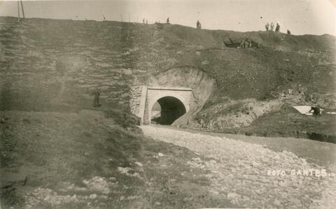
Información gráfica de los principales daños causados por las intensísimas lluvias del día 27 de enero de 1948 / Red Nacional de los Ferrocarriles Españoles. Vía y Obras. 3ª Circunscripción
Date(s)
- 31/01/1948 (Creation)
Level of description
Unidad documental simple
Extent and medium
1 imagen(es). Dimensiones 78 x 128. Soporte en papel. Color bl. y n.. Orientación horizontal
Context area
Name of creator
Biographical history
Repository
Archival history
Immediate source of acquisition or transfer
Transferencia realizada en fecha 17/01/2011
Content and structure area
Scope and content
Km 103,300 de la línea de Puente Genil a Linares, dentro del término de Torredonjimeno. Vista del corte producido en la línea a causa del corrimiento de terraplenes. Se ve el túnel parcialmente tapado. Se aprecia un ténder descarrilado y hundido en unos cuatro metros de tierra. En la parte superior del puente se ve a los técnicos valorando los daños.
Appraisal, destruction and scheduling
Accruals
System of arrangement
Conditions of access and use area
Conditions governing access
Conditions governing reproduction
Language of material
Script of material
Language and script notes
Physical characteristics and technical requirements
Buena
Finding aids
Allied materials area
Existence and location of originals
Existence and location of copies
Related units of description
Notes area
Alternative identifier(s)
Access points
Place access points
Name access points
- Renfe (1941-2004) (Subject)

